Grand Falls, Nuveau Brunswick – August 21

From a campground south of Perce we proceeded to NB on Highway #132. Debbie started questioning whether we were on the right track. Unfortunately we had bypassed our correct turn off by 75 kms. Later the same day I said to Debbie; “We should be in Edmonston in an hour”, Debbie responded with “Warren, that’s the wrong direction”. Fortunately that was only a 30 km mistake.

We were, by then, both getting a little grumpy but decided that we were learning some important lessons.

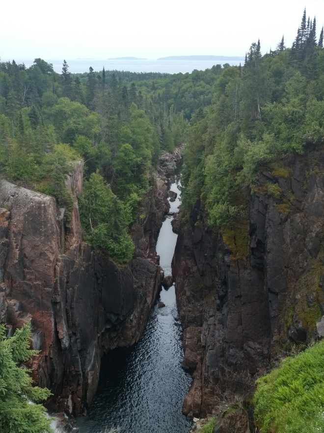
We got exceptional assistance at the Grand Falls tourist information office. We asked about campgrounds and the enthusiastic and knowledgeable lady asked what services we would need. We said we really didn’t need any services, she said then why don’t you just stay right here at the visitors centre? We did and had a very pleasant evening viewing the falls and walking along the canyon of the St. John R. Our mood improved substantially.

We awoke after a good nights sleep and took the suggested scenic route to St. Stephen’s. Along the way we visited the longest covered bridge in North America (over 1200 feet). We wondered why they covered their bridges? No one could answer? We visited the Covered Bridge potato chip factory, the McCann potato museum, and an interesting small town railway museum.  .

August 22 and 23 we took a room in St. Stephen’s toured the Ganong Chocolate Museum/factory and generally relaxed and regrouped prior to moving to St. Andrew’s for the Pleasure Way owners rally.

Some recent pictures along the way.

One of the complications we are facing is collating pictures taken by my cell phone, Debbie’s cell phone and our Panasonic Lumix camera. Here are a couple of recent photos and one video taken off the Panasonic camera:

P1010221

Perce Rock from a distance (ignore the wires)

Coming from the town of Gaspe getting our first glimpse of Perce Rock.

P1010226

Perce Rock up close.

The town of Perce was very touristy and we could not understand what attracted people here once they had had a good look at the rock with a hole in it. Bonaventure Island might have been interesting but we did not go there.

https://drive.google.com/file/d/0B7Z1r1YTyO9ONG5EYXRtWEhVdTg/view?usp=sharing

The above link is to a 30 second video taken just south of Perce. It struck us as not only beautiful but fairly typical of the type of scenery along the Gaspe. The purple flowers are fireweed (Epilobium Anagustifolium) common in burnt areas of Alberta and BC but very common along the Gaspe.

We travelled today from Grand Falls, NB to St. Stephen’s on the Bay of Fundy. Interesting day – potatoes, railway, covered bridge and potato chip factory.

Hard to keep the blog up to date!

It is now August 22 and we are in Grand Falls, NB. We have spent the last number of days circumnavigating the Gaspe peninsula.

https://www.google.ca/maps/@47.9696718,-67.0658877,7.68z?hl=en

Some quick notes on the Gaspesie;

Hilly forested terrain, every river valley has a small village along the coast. Mostly well kept houses on large lots with nicely groomed lawns,

Many campgrounds populated with large rv trailers, lots of Gites (B&Bs),

The history of the Gaspe was very interesting, from the strategic razing of the population by British general Wolf on his way to the Plains of Abraham, to the important and substantial commerce surrounding the cod fishery and whaling. In the early to mid 19th century fishermen from the British isles of Jersey and Guernsey settled in the Gaspe and founded the cod industry (catch, process and dry and salt the fish and then ship to Europe.) The town of Gaspe was a busy and thriving place.

During WWII the Germans sunk more than 20 ships leaving the St. Lawrence for Britain. Submarine nets and artillery batteries were installed to thwart a possible German invasion (a repeat of the General Wolf scenario).

It is 8:30 am and time for us to hit the road. Talk to you soon.

Some added info relating to last post.

I have just downloaded a program (using McDonald’s wifi) a program called “Open Live Writer” which allows me to draft blog entries off line. This should give us more freedom to document our journey without having to be internet connected. We can just upload when it is convenient to connect. Anyways, here goes:

Eardley Escarpment

This is a picture taken from the Gatineau Hills looking North along the Eardley Escarpment on the Western edge of the Gatineau Hills. To the left is the flat lands of the St. Lawrence lowlands and the Ottawa R., just barely seen on the left edge of the photo.

Debbie Gatineau to St Lawrence Lowlands

From the Gatineau Hills looking South towards Ottawa with the Ottawa River in the background.

Here is a link to a picture of the historical lock between L. Superior and L. Huron. Huron is lower and in the distance.

https://drive.google.com/file/d/1RtHfzyEepNokARUjS3K5ObbxDtiPfyjUFg/view?usp=sharing

Travelling along the Gaspe we noticed a disc-golf course and stopped to play. Short 9 hole course but Debbie lost her favourite driver disc here.

Disc Golf along the way

We have slowed down and have been spending time “smelling the roses” and taking in the sights (sites). Hope to update soon.

We have come to love and appreciate Walmart

It appears that fees at RV campgrounds run between $30 to $45 per nite. When you arrive somewhere after supper hours and expect to carry on first thing the next morning I find it really difficult to justify the cost. Walmart becomes a very enticing option. No hassles – just park at the unused end of their parking lot, listen to the radio or a podcast and then sleep peacefully. Some of the campgrounds we have driven by pack you in cheek to jowl making Walmart look all the better.

No posts over the last week – too busy making miles, but here is a quick summary:
Kindersley to Yorkton: moving eastward across the flat prairie we moved from grassland biome(mostly cultivated) to aspen parkland. We poached a visitor information centre parking space in the pouring rain.

Yorkton to Winnipeg: Turning southward from Dauphin we travelled through Riding Mountain National Park. A transition from relatively flat aspen parkland to large hills and boreal forest – tamarack, conifers, deciduous mixed forest and patches of muskeg. We exited this terrain to come upon land flat as far as the eye could see, all the way to Winnipeg. Stayed at Walmart.

Winnipeg to Kakabeka Falls (near Thunder Bay): Wow!! What a change in scenery. South of Winnipeg seemed like boreal forest and then about the border with Ontario we encountered the Canadian shield with its granite road cuts of varying hues. Lake of the Woods was an amazing intricacy of islands and channels extending for many 10’s of miles, Kenora was a tourist town, something between Banff and Waterton.
Water chasm to L. Superior

Thunder Bay to Wawa: Along drive to Wawa, slept in visitor centre parking lot.

Wawa to Sault Saint Marie: Arrived in S.S. Marie early mid afternoon and toured the S.S. Marie Canal National Historic Site, a well maintained park along the canal between L. Superior and L. Huron. There is a working lock with a 30 foot rise used by tourist boats and recreational water craft. Very interesting history. Freighters and commercial ships now use the St. Lawrence Seaway whose locks between Superior and Huron are on the US side of the border. We tried to overnite in the park (no signs of prohibition)but were asked to leave, moved outside the park and were asked to move once more. Houses are older and many with brick exteriors.

S.S Marie to Pembroke: Toured Sudbury along the way. Pleasant forest along the way and glimpses of the Ottawa R. along the second half. The installation of a wifi antenna on the van roof was very worthwhile as I can generally get a good connection at Walmart and McDonald’s parking lots. Rarely get a wifi signal from same location by cell phone. We have a glitch getting alternate current to plugs in our van via shore power or generator. This needs to get resolved so that we can re-charge our ebike batteries. Stayed at Walmart.

Pembroke to St. Hyacinthe: Toured Gatineau Park along the way. Very nice park and obviously very popular. Lots of bicyclists. The geology of Gatineau Park, which encompasses these foothills, is related to the Eardley Escarpment, which is a fault line that lies along the southern edge of the hills. This escarpment makes the park an attractive location for rock climbers and hikers, offering a beautiful view of the relatively flat fields below, which extend to the Ottawa River. The Eardley Escarpment is part of the northern side of the Ottawa-Bonnechere Graben, which is an ancient rift valley.
Carried on through Ottawa, across the Ottawa R. Busy highway and area less pastoral than I had imagined – lots of light industrial and warehouses. Walmart again.
Gatineau Park

St. Hyacinthe to Riviere-du-Loup: Stayed at a campground to replenish our fresh water and empty our grey and black water tanks. Somewhat better than Walmart for $33.00.

Finally!! On our adventure

Five days later than we had projected, at 3pm yesterday we left the comfort and familiarity of our home. Robson was given last minute instructions to care for everything. Debbie and I sat in Prancer (our Sprinter campervan)idling in the driveway, apprehensive to leave and reviewing the list of not to be forgotten essentials. About 9:30 pm we found a pleasant but rustic campground in Kindersley, SK. After a good nights rest we took a surprisingly pleasant walk around the lagoon in Kindersley Regional Park.
Kindersley Regional Park